Altnaharra
Altnaharra is the most beautiful place-name in Scotland. Say it a few times, roll it around – Alt-na-har-ra. It has a music and a glamour about it. The hamlet of Altnaharra is the site of a Met Office weather station, and its northerly latitude and location at the western extremity of Loch Naver, deep in the Sutherland interior, mean it is often in winter the coldest place in the country – in 1995 the UK’s lowest ever temperature of −27.2 °C was recorded here. This is all most folk know about Altnaharra, having never had the occasion to visit. The name, however, has been with us since we sat as children on kitchen stools eating our tea, the evening weather forecast on the telly in the background, lending it a kind of misty nostalgia. I felt that anywhere that dared to be called something as extravagant as Altnaharra must be worth seeing, at least.
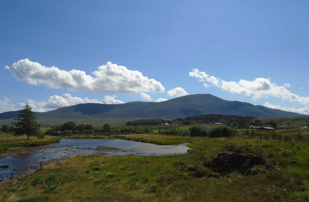
Alnaharra from the north, Ben Klibreck, the River Mudale (photo by Gemma Smith, July 2018)
Altnaharra is an Anglicised version of Allt-na-h-Eirbhe, Gaelic for ‘burn of the dividing wall or boundary’. The burn the settlement was named after was recorded as Allt na h-Aire by the 1878 Ordnance Survey six inch first edition, but William Roy’s 1747 military survey map of Scotland has Aldnaherive, a phonetic spelling of the Gaelic name. This seems at first a disappointingly prosaic meaning for a name of such romance. It is, however, a very old word for ‘fence or boundary wall’, coming from the Early Gaelic word airbe, ‘ribs, fence’, suggesting the wall itself was ancient, if presumably it was there when the burn was named by Gaelic speakers. In W.J. Watson’s The Celtic Place-names of Scotland, he says:
In certain parts of Ross and Sutherland there are walls, some of which run for many miles, made of turf and stone, which give rise to a number of names involving this term. Allt na h-Airbhe, ‘burn of the wall’, occurs in Eddrachillis and in Kildonan, but the best-known example is Allt na h-Eirbhe, Altnaharra, near the head of Loch Naver, spelled Aldnaheiribh in Macfarlane [Geographical Collections relating to Scotland, 1906]. In this case the wall is said to run from Ben Vragie near Dunrobin to the stream which enters the head of Loch Naver; I have followed its course for some miles through Dunrobin Glen.
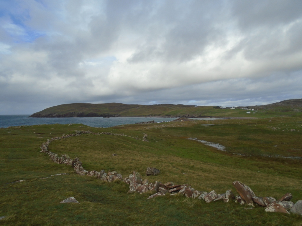
The ‘dragon’s tooth’ stone wall at Clachtoll, Assynt – the broch can be seen in the distance centre-right (photo by Gemma Smith, August 2018)
I arrived in Altnaharra having hitched a ride in the back of a friendly Dutch couple’s campervan. I had quit a seasonal job in Ullapool in order to take advantage of 2018’s dry, hot summer, and spend the rest of it living in my tent and various bothies – I decided it would make a better story that way. I started with a part of Sutherland I’d never seen before – the long, lonely, mostly single-track road that meanders south from Tongue to Lairg. After a few days’ camping at Tongue, I moved on to the bothy at Achnanclach (achadh nan clach, ‘field of the stones’), and remained there for almost a week, spending days sunbathing on the red sandy beach on the banks of Loch Craggie.
I was woken on the first night by two six-foot-plus, muscular guys with very neat haircuts in full combat gear, who were even more startled to see me than I was them, and explained in thick regional accents that they were ‘just deer-stalking, love’. Of course – that will be why you needed to case the bothy, I thought, and left them undisturbed in their pretence. This most sparsely-populated corner of Scotland lends itself well to military training exercises. After they left I didn’t see another human for three and a half days.
I walked straight onto the road and got a hitch to Altnaharra at the first attempt. After almost two weeks away from hot water and upholstery I was keen to treat myself to a bed for the night, and started with the hamlet’s one hotel, built on the site of an old drovers’ inn, and now used mainly by anglers.
There is not much now, at Altnaharra – the hotel, a sporting lodge, a small cluster of houses, and a tiny Caravan Club site a couple of miles down the road on the loch’s north side. Whilst camping at Tongue I jumped on one of the two buses a week that go along the north coast road, and visited the Strathnaver Museum at Bettyhill, where a map shows the settlements that were here before the Clearances. Strathnaver was at that time studded with townships, some housing more than ten families – in 1811 it was home to 1558 people. By the time of the 1851 census, that number had dropped to just 227 souls. Altnaharra was previously a comparatively minor settlement, with just two households resident. It is now the most significant for many miles around – at least seventeen and a half miles from anywhere else you might even call a hamlet, in any direction. The green and pleasant land of Strathnaver lies near-empty still. As Patrick Sellar wrote of the infamously brutal clearance of the area:
Lord and Lady Stafford were pleased humanely to order the new arrangement of this country. That the interior should be possessed by Cheviot shepherds, and the people brought down to the coast and placed in lots of less than three acres, sufficient for the maintenance of an industrious family, pinched enough to cause them to turn their attention to the fishing. A most benevolent action, to put these barbarous Highlanders into a position where they could better associate together, apply themselves to industry, educate their children, and advance in civilisation.
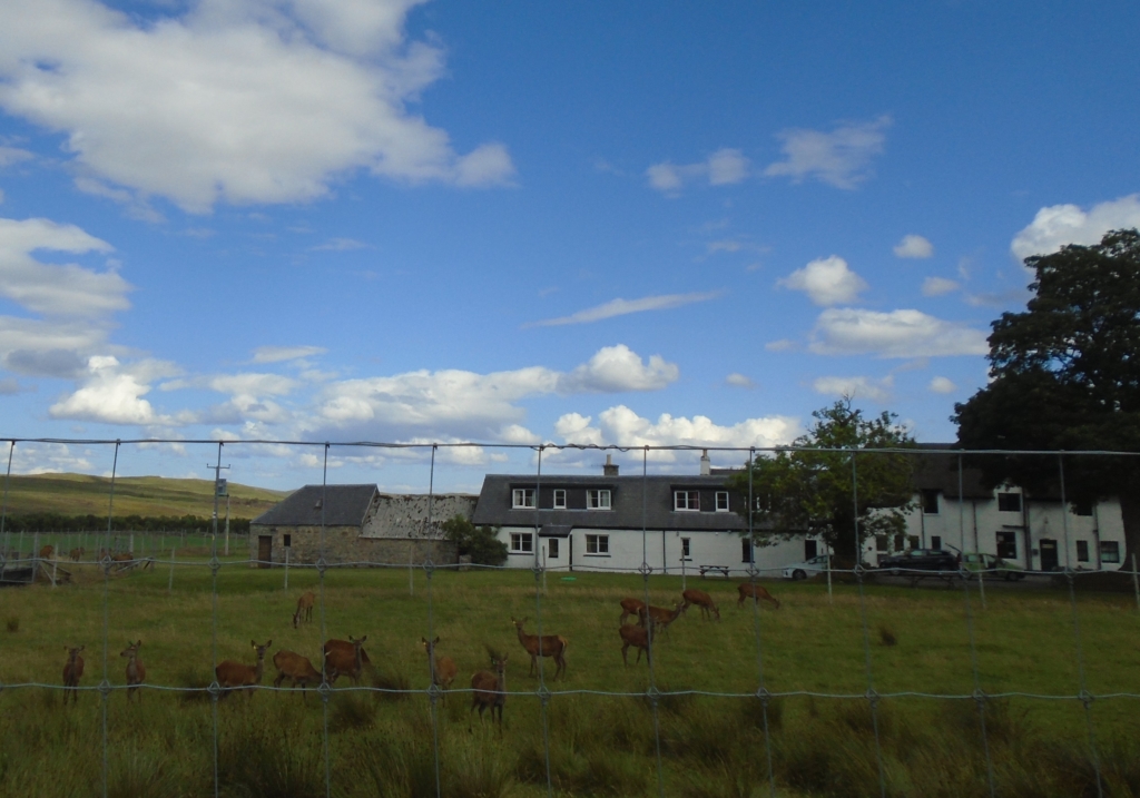
Deer outside the Altnaharra Hotel (photo by Gemma Smith, July 2018)
In the Alnaharra Hotel you will find tartan upholstery, framed pictures of Highland landscapes, and a game-heavy dinner menu. That afternoon the place was deserted. The public bar is a small, plain side-room, where I later ate fish and chips for dinner, stretching out a cup of tea until a reasonable time to return to my tent, the only other customers a quiet, middle-aged couple who were not up for chatting.
There was no room for me at the inn. The town’s one B&B was also full. The owner did, however, make me a cuppa and let me charge my camera battery, and we sat drinking tea and eating biscuits in his conservatory. Hearing his English accent, I asked what brought him to Altnaharra. He and his wife moved up about 25 years ago, having fallen in love with the area. They like the peace and quiet – you have to round here, he said. It’s nice to see a wee school still at least, I offered, still some life about the place – I had passed the school on the walk in. Ah, he said, that’s been mothballed for years now… It wasn’t the first time it had closed – the population of the village had dwindled before, and the estate had advertised for workers with families to move up. Now all those kids had been through the school and grown up, moving on to high school and employment elsewhere.
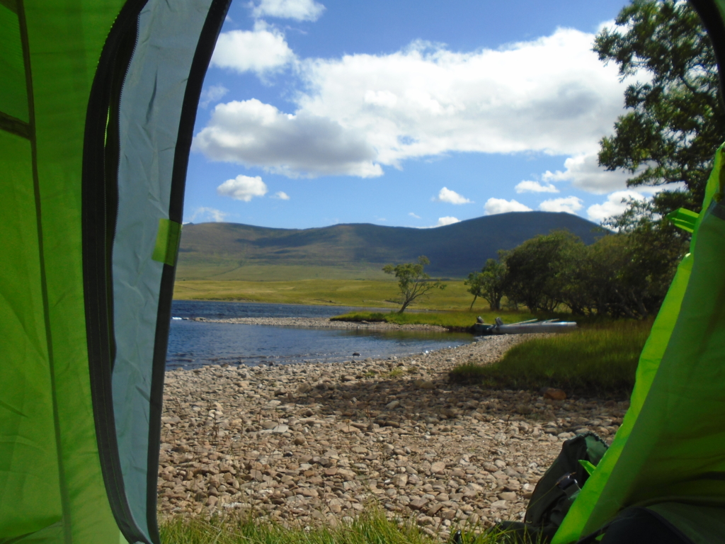
I made my way back along the road, past the hotel and the lodge, down a track that led right to the edge of the loch, and found myself a wee spot at a secluded bay, past some scattered birch woodland. It wasn’t the worst place I’ve ever pitched my tent.
A view of Ben Klibreck and Loch Naver (photo by Gemma Smith, July 2018)
Loch Naver takes its name from the River Naver, which flows north for almost twenty miles from here to meet the sea at Bettyhill. The River Naver featured as the Nabaros on the classical geographer Ptolemy’s second-century map of Britain. River names are often very old; Watson thought this one derived from nabh, an Indo-European root meaning “cloud”, perhaps referring to mists coming off the water. Prior to the Clearances, the largest settlement at this most westerly end of the loch was Klibreck, which occupied the verdant grassy slopes on the south banks of the loch, at the foot of the mountain of the same name.
Klibreck comes from the Gaelic Cleith-Bric, at first an ambiguous name. Cleith has a variety of meanings in Gaelic, most prominently a ‘stake, post’, or a ‘concealement, hiding-place, residence.’ The second element comes from breac, usually an adjective meaning ‘brindled, speckled’. As a noun in this case it refers to a brindled or speckled creature – most often a trout or salmon, here it signifies a wolf. The Ordnance Survey Name Books, collected when the first OS maps were being compiled, explain that Cleith-Bric is ‘Den of the Wolves’, or at least that is how it was understood when recorded in 1878.
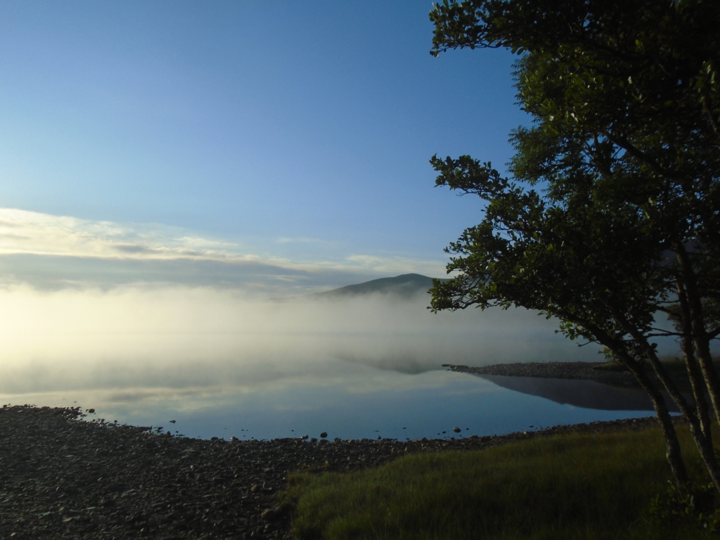
Loch Naver shrouded by mist just after sunrise (photo by Gemma Smith, July 2018)
The hillside at Klibreck is dotted with the remains of structures dating from the Iron Age to the early 19th century; there are cup-and-ring marked stones, hut circles, and a broch on an island on the loch. Among the ruins are a pair of standing stones over a metre tall, one featuring an incised Celtic cross, first noted by archaeologists in the 1860s and thought to date from the early medieval period. It is believed that a chapel lay nearby, although little remains now of its structure. East of Klibreck lies what is left of Ruighnasealbhaig, correctly Ruighe na Sealbhaig, ‘shieling slope of the sorrel’. Presumably once a grazing, by the eighteenth century the ground here had been so improved by generations of manuring by domestic animals that it became a permanent habitation. It is likely that Altnaharra itself also began as a shieling of the àirigh or ‘dairying site’ type – these were often named after the burn they depended on for the supply of clean water essential to food production. As pre-‘Improvement’ pastoralism enriched the land, the settlement of Cleith-Bric would have expanded into these outlying areas to meet the demands of what was once a thriving population. This place was continuously inhabited for millennia – it is its relative emptiness now that is the historical aberration.
Ben Klibreck in turn therefore does not mean, as the Ordnance Survey Name Books claim, ‘Mountain of the Den of the Wolves.’ It was the settlement of Cleith-Bric that was named after the wolves’ den – and the ‘wolf’ could potentially have been a nickname for the person who first lived there. Ben Klibreck was then named after the settlement, and is more accurately ‘Mountain of Klibreck.’ The distinguishing feature of the mountain was not a wolves’ den, no matter how neatly that may play into the modern ‘wilderness’ narrative. That giant, 962m slice of Moine schists and gneisses – some of the oldest rocks in the country – was named for the human habitation that nestled below its north face, attesting instead to the significance of the people who formerly lived in its shadow.
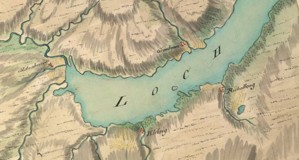
The settlements of west Loch Naver, as depicted by William Roy in his 1747 Military Survey of Scotland (picture National Library of Scotland Maps)
After dinner in the hotel I returned to my campsite to find the midges were out, and had no option but an early night. As I ate a bar of chocolate in my tent I heard a deer munching on the grass nearby. It drifted closer and closer, until I could hear its breath out in the windless dusk. I listened to the sound of its front hoof scratching an itch on its great meaty haunch, just inches away from where I sat. Suddenly, it stopped, sniffed the air, and realised how close it had come to a human. It bolted dramatically, careering away through the woods. The next day I found the biggest deer tick I’ve ever seen on the outer layer of my tent.
It was a supernaturally calm night. I woke in the early hours and stepped outside, and was frozen to the spot by the sight of the stars and the giant, almost-full moon reflected off the glassy surface of the loch. I fell back to sleep listening to the regular, weighty splashes of fish leaping out of the water, punctuating the deep silence outside.
In the morning I woke to sunshine and a hearty breeze, and enjoyed the luxury of breakfast sat out on the pebble beach, undisturbed by biting insects. I waded out into the shallows of the loch to wash – I had a reservation at the Crask Inn that night and needed to be half-presentable. I set off again on the road out of Altnaharra, the road that skirts around the west side of fair Ben Klibreck, and continues onwards through the vast expanse of moorland that lies between here and Lairg, twenty miles to the south. Altnaharra is the most beautiful place-name in Scotland. To me those four syllables contain a microcosm of Highland history. But who will call this place home, even fifty years from now?
A thoroughly-researched piece of travel writing is exactly the sort of piece I needed to interrupt the election brain-bleed. Thoughtful and illuminating. Thank you, Gemma.
I loved your piece Gemma, great start to my day! I’m ancient myself now, but my grandfather was a shepherd in the hills around Gordonbush.
Just lovely Gemma; the very thing to refresh me after a morning’s election leafletting. Strathnaver is in itself of course highly political, and celebrated in literature because of that. McGrath’s ‘The cheviot, the stag and the black, black oil ‘ wasnie the first. Neill Gunn’s novels, although he was from the Caithness coast, feature it too. And Ben Klibreck is with Ben Hope and Foinaven (the latter only recently promoted to munro, it’s a corbett in my 1990 SMC guide), one of the most remote munros.
I think Foinaven is still a Corbett.
All the more reason to climb it in my book.
But both Klibreck & Hope are fantastic Munros. IMHO the view from the summit of Ben Hope is one of the best in Scotland.
The last three sentences really pack it all in, Gemma. On an equally chilling note, the Met Office’s weather observations website says that it’s 5.7° C at Altnaharra as I write this – we’ve got a long way ahead of us yet before we get to summer-of-2018 levels…
Superb
Great piece of writing ,fair gives me the urge to haul my auld backside up the hills right now.
Beautiful
Beautifully written excellently researched article.
Lovely piece. Thank you! Took me back to a two-day hike I did many years ago from the Crask Inn via Loch a’ Bhealaich and through Ben Armine to Gordonbush and Brora. That same sense of an emptied, rather than an empty, landscape – of stunning beauty. The midges were out in force, though – breakfast was breakfast for them too!
Great article. Stayed at Crask Inn some years back and it did not strike me as a place one needed to be presentable at! Idiosyncratic would be a kind description. Decent restaurant mind and good people there. Midges were appalling!
Enjoyable article!
Place names with `airbhe’ don’t only refer to human boundaries. There’s a bay 1 km south of Dail on the Kyle of Durness called Geodh na h-Airbhe, where I think the name refers to the huge wall-like rock dividing the beach –
http://www.macs.hw.ac.uk/~denis/photos_de/geodha_na_h-airbhe/slides/P1040439.html
While on place-names, I think Gemma protests too much about Ben Klibreck not being named after the wolves: if it’s real wolves referred to, surely both settlement and hill are named after their den, it’s just that the village isn’t explicitly called `settlement of the den of wolves’. And as to the `wilderness narrative’, did the extinction of wolves help the human population? Or might they have made it harder for the sheep to clear the people?
Hi Denis – glad you enjoyed it. Ben Klibreck is what we call in onomastics an ‘ex-nominee’ or ‘existing-name’ construction – in toponymic gazetteers you will find such constructions marked ‘en’. Klibreck was in this case the existing name – i.e. it came first – which then gave its name to the mountain. So Klibreck was named after the wolves’ den, and then Ben Klibreck was named after Klibreck – the settlement. If you are interested in onomastics, WFH Nicolaisen’s ‘Scottish Place-names: Their Study and Significance’ (London, 1976) is a good place to start. Sadly I don’t think a few wolves would have done much to stop the Highland Clearances! Slàinte mhath.
As the SNP Highland Councillor for that part of Sutherland, I travelled the single track road from Lairg to Tongue through Altnaharra half a dozen times a month. But sometimes I would turn left along the Hope Road. I’m sure on an autumn evening as the sun set there was no more beautiful place in the world than over the peatlands of Strathmore. I’m sure that could have been the naissance of Visit Scotland’s Autumn Gold campaign.
My brother and I ventured into to the lounge bar of the hotel at Altnaharra when we were hostelling in the North in July 1979. We encountered an elderly lady with a very posh accent who had spent most of her life in the Colonies. She referred to the barman – who must have been well into his forties – as “the boy”.